Improved Data Visibility and Accessibility

In the ever-evolving realm of industrial machinery management, staying ahead of the curve is imperative. This article delves into three transformative feature updates for the DataPortal to make machine tracking and data analysis more manageable for your day-to-day work. From the introduction of Maps with color-coded tracks to bring your data to life and Map-Report with color-coded tracks for multiple machines, empowering users with comprehensive insights into operational metrics, to the implementation of Hierarchical Geo Data, streamlining machine filtering, and enhancing geographical analysis, these advancements are poised to be the way businesses approach operational efficiency and data-driven decision-making.
Maps and Map-Report with Color-Coded Tracks
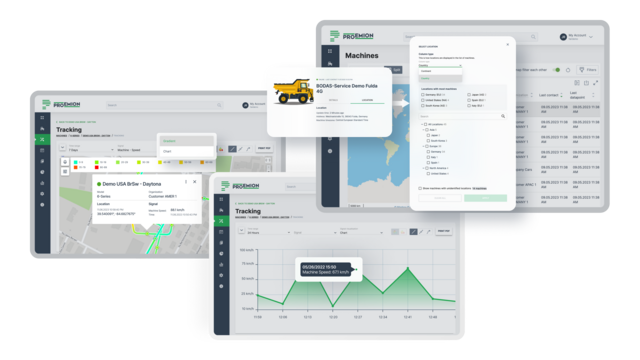
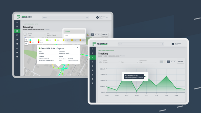
Tracking each machine's movements and performance is crucial for your business. In response, we developed two special feature updates: Maps with color-coded tracks and Map-Report with color-coded tracks for multiple machines. This innovative advancement empowers users to visualize signal data on a map, with the added functionality of color-coded tracks, allowing for comprehensive documentation of crucial operational metrics over time.
Tailored to cater to the diverse requirements of various sectors such as agriculture, construction, and government, this feature addresses common pain points experienced within the industry. Facilitating the effortless monitoring of work quality and location ensures adherence to contractual obligations and builds credibility with clients and regulatory authorities.

A few weeks after introducing the signal value-based color coding for tracks, we are adding support to display multiple machines with color tracks in parallel at the map report.
Expanding on this feature, we also created Map-Report with color-coded tracks for multiple machines. The Map-Report can now seamlessly showcase color-coded tracks for numerous machines simultaneously, offering users a richer and more insightful mapping experience.
Introducing color-coded tracks in our mapping system fosters strategic planning and resource allocation. By analyzing variations in key metrics across different locations, machine owners can make informed decisions about resource deployment, identify areas for improvement, and enhance overall productivity and profitability.
Additionally, the feature allows machine owners to accurately quantify materials used at specific locations, ensuring precise invoicing and enhancing transparency in financial transactions. By efficiently tracking the quantity of materials utilized at each site, users can ensure that billing accurately reflects the resources used, fostering trust and reliability with their clientele.
Hierarchical Geo Data
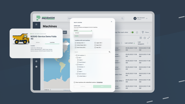
We created Hierarchical Geo Data to enhance how you filter and view machines in the DataPortal. With the ability to sort by continent or country, users can now create tailored reports and efficiently manage service routes based on specific geographical criteria.
Driven by customer demand, this feature fulfills a variety of business needs across diverse segments, including product, service, and sales management. Service partners can seamlessly plan and optimize service routes by facilitating convenient filtering down to regional machine data, enhancing overall operational efficiency.

Our solution incorporates a cost-effective and efficient local library for reverse geocoding, eliminating the need for detailed address information and minimizing expenses associated with location changes. Additionally, in combination with the "Countries, Languages & Continents Data" library, our system accurately maps out hierarchical geo data, providing a comprehensive and standardized view of machine distribution across continents, countries, and regions.
With a comprehensive output structure encompassing Continent, Country, and State/Region, our Hierarchical Geo Data feature ensures seamless navigation through varied administrative area levels, allowing users to efficiently access and analyze relevant machine data based on specific geographical parameters.
Improved data visibility for your daily workflow
These three features are only part of the many small but significant steps we regularly take to enhance your DataPortal experience. Therefore, we are always happy to receive feedback from our customers and support them.
If you have questions on any of these features, do not hesitate to contact us or go to documentation to learn more about the Maps and Map-Report with color-coded tracks or the Hierarchical Geo Data.
Never miss a product update again.
Sign up for our regular newsletter with the most important product updates.